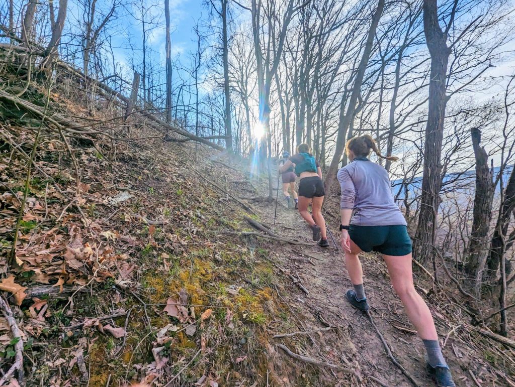
I huffed up the slope, so steep I had to scrabble at the trail with my hands. My best friend and her dad were way ahead of me, tromping up the hill with hiking sticks and backpacks. My Harry Potter t-shirt was soaked in sweat, my fingers swollen like little sausages. Dry leaves blew across the hard-packed path.
Finally I hauled myself onto a flat stone outcrop where my friend and her dad waited.
I flopped down on the rock and tore off my sneakers, wiggling my toes in the hot September sun. A light breeze lifted my sweaty bangs off my forehead. I scooted toward the edge of the rock and peeked out.
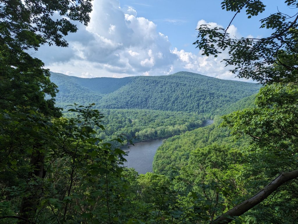
A turkey vulture soared at eye level on a hot gust of wind. Far below, the river curved in a graceful swoop. On either side, green ridges rose to gentle peaks before folding back into dark hollows. A miniature-looking train track cut through the valley along the water’s edge.
We sat at the overlook for a few more minutes, eating our granola bars. My friend snapped a picture of me on a disposable camera. I lifted my arms up, flushed and exhausted from our big climb.
–
That short hike was my first experience on the Laurel Highlands Hiking Trail (LHHT, for short) – four miles roundtrip from Ohiopyle to the overlook at mile marker #2. It was a pretty big accomplishment at the time.
That overlook has a lovely view of the Youghiogheny River and Sugarloaf Knob. There aren’t many like it in the Pennsylvania Laurel Highlands. Our ancient mountains once stood taller than the Rockies, but 200 million years of erosion have worn them down to steep, green rollers that go on forever. Getting out of the canopy is tough, but the LHHT always provides.
The 70.5-mile LHHT makes up the majority of Laurel Ridge State Park. It stretches from the Youghiogheny River Gorge in the south to its northern terminus in the Conemaugh Gorge near Johnstown, PA. The trail passes through Fayette, Somerset, Westmoreland, and Cambria counties, mostly on public lands. The LHHT is the longest hiking-only path in the Youghiogheny River watershed.
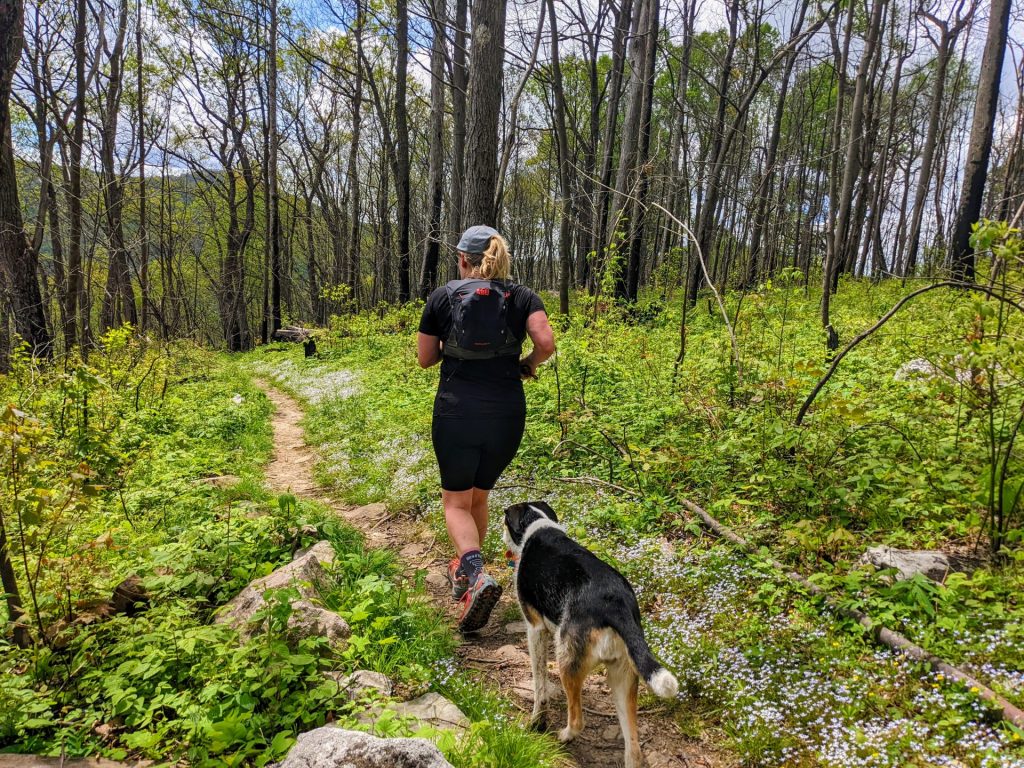
From dense hemlock groves to rocky ridgetops, the path showcases some of the most unique environments in the Laurel Highlands. Hikers can see native mountain laurel blooming in the summer, pick their way through rock mazes carpeted with ferns, and pause for a refreshing splash in a cool mountain stream.
The LHHT isn’t the longest trail in the state, but it is one of the toughest. From end to end, through-hikers will gain and lose over 10,000 feet. It’s not a true backcountry route (you’re never more than a few miles from a road or a house), but the lack of cell service and dense overstory make it feel pretty darn remote.
Still, there are plenty of conveniences. Lean-to shelters, restrooms, and water spigots are dispersed every 6-10 miles for long-distance backpackers, and bright yellow blazes mark the way. No wonder some 113,000 hikers visit the trail every year.
In 2026, Pennsylvania is celebrating 50 years of the LHHT. The story of the trail is one of community, conservation, and recreation planning that spans generations.
–
The first folks to explore the ridges and valleys of Pennsylvania were indigenous people who farmed, hunted, and lived on the land. The Monongahela people were the first to inhabit these lands, eventually giving way to the Iroquois. The Iroquois didn’t settle the region, but used these lands for hunting and gathering. Lenape and Shawnee settlements popped up in the area as well. But by 1630, European settlers arrived and forced the indigenous folks west over the hill.
The Europeans supported themselves by farming and making iron, an industry that was critical to our nation’s development. People quarried stone to build iron furnaces that melted ore into iron. Our plentiful waterways powered the bellows, which supplied oxygen for the raging fires. Those fires needed lots of fuel – each furnace could consume up to an acre of forest every day.
As iron gave way to steel, the advent of railroads sped up deforestation. By 1940, many parts of the mountain area were barren, with black stumps where great hemlocks used to stand. Many of the old, indigenous-made paths over Laurel Hill were made into roads. Railways sprung up, connecting the ridges and valleys into a major industrial network. For a while, the area was booming.
But every boom comes with a bust. Lucky for us, there were some people more invested in protecting the land than extracting its resources.
In 1955, an Army veteran and forester named Maurice K. Goddard was appointed secretary of the Department of Forests and Waters (the predecessor to our current Department of Natural Resources, or DCNR). At a time when there were just 44 state parks in Pennsylvania, Goddard had big goals to build a park within 25 miles of every Pennsylvanian.
Enter the Western Pennsylvania Conservancy (WPC), a non-profit dedicated to protecting natural lands in Pennsylvania. They wanted to conserve as much of Laurel Hill as possible. And the organization didn’t just want a State Park – they wanted a hiking trail that would show off the value of nature and inspire a new generation of environmentalists.
In 1966, the Western Pennsylvania Conservancy acquired 11,230 acres along Laurel Ridge, ranging from the Youghiogheny River to the Conemaugh River. The Conservancy conveyed that land to the Commonwealth, and work started on the corridor that would eventually become the Laurel Highlands Hiking Trail.
Two years later, a group of ambitious local Boy Scouts assembled for the first through-hike of the yet-unnamed LHHT. They just had compasses and a map from WPC. They mostly bushwhacked along the trail corridor, a first descent of the route.
Later that year, the state hired Neilan Engineers of Somerset to actually design the trail. At the same time, the Department of Forests and Waters assembled a task force to build shelters, trailside water supplies, and other conveniences.
Work finally started in the early 1970s. The trail crews were mostly boys in their teens and early 20’s who needed a summer job. They made steps, built bridges, cut trees, dug switchbacks into the steepest slopes, and painted the first iconic yellow blazes.
Meanwhile, the Department of Forests and Waters was designed the iconic shelter areas, spread out every 6-12 miles along the trail. Each overnight area had five rustic, wooden lean-tos with stone fireplaces, space for 30 tents, two latrines, and a water supply.
By September 1972, 30 miles of the trail were cleared, blazed, and open to day hikers. By 1974, the first three shelter areas were finished, and in May the first 32 miles of the trail from Ohiopyle to Route 31 were officially opened.
At the end of June, the trail was 57 miles long. Finally, the whole 70 mile trail was finished in 1976, complete with eight shelters. In that first year, about 75,000 hikers ventured into the forest on the LHHT.

–
Even though the trail is finished, the work is never really done. There are stairs to maintain, bridges to rebuild, fallen trees to cut, and shelters to look after. To get eyes on the trail, DCNR staff works with the PA Ridge Runners volunteer group. Volunteers hike sections of the trail and issues like fallen trees and trail damage. Then the park dispatches staff to fix the problems as fast as they can.
Twice a year, the Ridge Runners complete their own projects, hauling buckets of gravel and wooden posts into the middle of the woods to fight ongoing erosion problems on the LHHT. (After all, southwestern PA is prone to jungly wetness all year long.)
Mike Mumau, DCNR Laurel Highlands Division Manager, was the longtime manager of the Laurel Hill State Park Complex. He’s more than familiar with the challenges of managing a 70-mile state park.
“[The LHHT] covers four counties and over 30 different municipalities,” says Mumau. “It’s a lot of ground to cover. But the beauty of the trail is that it’s nature on its own terms. “The challenges that we face have pretty straightforward approaches.”
Despite any management challenges, the LHHT is still one of Mumau’s favorite park experiences in Pennsylvania.
“It immerses you in nature, more than a typical state park. The diversity of the experience is outstanding,” he says, recalling his first backpacking experience on the LHHT from Ohiopyle to Bidwell, a beast of a climb with a loaded backpack.
“That hike reminded me how out of shape I was, and that I did have hip flexors,” Mumau laughs. “But you can also find sections of the trail that are easy and enjoyable.”
He’s right. Some trail sections are flat and rolling, with little elevation gain and few rocks – perfect for beginners or anyone getting back into hiking. Others are wildly steep, wet, and rocky – a challenge for even the fittest athletes.
In fact, athletes are especially drawn to the trail’s rocky charms. Each year, hundreds of runners take to the trail for the Laurel Highlands Ultra Run, an event that’s almost as old as the trail itself. Trail runners traverse the entire 70 miles from Ohiopyle to Seward in teams, pairs, or solo. There’s also a shorter, 31-mile option that ends roughly halfway.
This “ultra challenge” started after brothers Joe and Paul Butchko discovered the 70-mile Laurel Highlands hiking trail in the late 1970s. They had a simple idea: run the whole thing. After a first attempt saw no finishers in 1979, the Laurel Highlands Ultra ran for the first official time in 1980, with seven starters and four finishers. The race grew over the coming decades, but consistency has been key – the race has gone on every year since then, with no real changes to the course.
That’s not to say that everyone should try the LHHT in one go. Whether you wander a few steps to check out a cool flower, or you tackle the whole thing in one day, you’ll come away with a greater appreciation for this 70-mile nature corridor connecting two of Pennsylvania’s most significant river gorges.
–
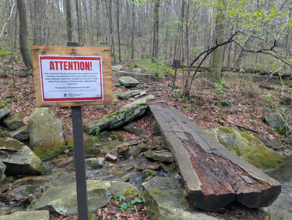
Right now, MWA is working to protect a creek that runs across the trail near mile marker 25. A target-shooting range at the top of the ridge has polluted the waterway, Blue Hole Creek, with lead and other heavy metals. Blue Hole used to provide hikers and backpackers with a fresh, cool source of water to filter on a hot day. Unfortunately, the water is no longer safe to drink.
Join our letter-writing campaign, and urge the PA DEP to take stronger measures against the shooting range! Help us protect this important natural resource on the LHHT!